Mongolia
Between sky and earth…
Gobi Desert
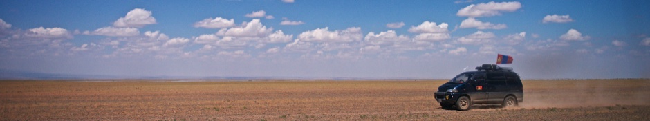
Racing. ©2012 Robert Prior
The Chinese also call it a desert, but the Mongols call it a 'gobi'—that is, a land of thin herbage, more suitable for camels than for cows, but capable also, if herds are kept small and moved frequently, of sustaining horses, sheep, and goats. The herbage comprises a high proportion of woody, fragrant plants. Gobi mutton is the most aromatic in the world.
Owen Lattimore, "Return to China's Northern Frontier." The Geographical Journal, Vol. 139, No. 2
My immediate memory of the Gobi Desert is, unfortunately, a faint memory of nausea brought on by hours of off-road driving. While I knew that we would be spending most of the trip in the Gobi, I hadn't realized that so much of that time would be spent driving from place to place. As the windows on our vans didn't open shooting while on-the-move didn't work very well — even if one was able to snap a shot at the top of a bounce, the colour cast and reflections made getting a good picture very tricky. (The one above is heavily cropped, and the only good shot of several hundred I attempted.)
My first impression of the Gobi, when Gee announced that we had been driving in it for a while, as that it was far greener than I expected. While I knew that sand dunes were rare, I'd imagined that one could drive for miles without seeing anything living — and yet we were never out of sight of plants, and while we couldn't always see animals the dung (and flies) were a constant reminder that the Gobi isn't really empty.
My first impression of the Gobi, when Gee announced that we had been driving in it for a while, as that it was far greener than I expected. While I knew that sand dunes were rare, I'd imagined that one could drive for miles without seeing anything living — and yet we were never out of sight of plants, and while we couldn't always see animals the dung (and flies) were a constant reminder that the Gobi isn't really empty.
Further Travels in the Gobi Desert
Continue reading about the Gobi Desert here:
- Ongiin Khiid
- Khongoryn Els
- Bayanzag
- Tsagaan Suvarga
- Baga Gazriin
Wikipedia Article
The Gobi (Mongolian: Говь, Govi, "semidesert"; Chinese: 戈壁; pinyin: Gēbì) is a large desert region in Asia. It covers parts of northern and northwestern China, and of southern Mongolia. The desert basins of the Gobi are bounded by the Altai Mountains and the grasslands and steppes of Mongolia on the north, by the Hexi Corridor and Tibetan Plateau to the southwest, and by the North China Plain to the southeast. The Gobi is most notable in history as part of the great Mongol Empire, and as the location of several important cities along the Silk Road.
The Gobi is made up of several distinct ecological and geographic regions based on variations in climate and topography. One is the Eastern Gobi desert steppe Ecoregion, a Palearctic ecoregion in the Deserts and xeric shrublands Biome, home to the Bactrian camel and various other animals. It is a rain shadow desert formed by the Himalaya range blocking rain-carrying clouds from the Indian Ocean from reaching the Gobi territory.
The Gobi measures over 1,610 km from southwest to northeast and 800 km from north to south. The desert is widest in the west, along the line joining the Lake Bosten and the Lop Nor (87°-89° east). It occupies an arc of land 1,295,000 km2 in area as of 2007; it is the fifth-largest desert in the world and Asia's largest. Much of the Gobi is not sandy but has exposed bare rock.
The Gobi has several different Chinese names, including 沙漠 (Shāmò, a generic term for deserts in general) and 瀚海 (Hànhǎi, "endless sea"). In its broadest definition, the Gobi includes the long stretch of desert and semi-desert area extending from the foot of the Pamirs, 77° east, to the Greater Khingan Mountains, 116°-118° east, on the border of Manchuria; and from the foothills of the Altay, Sayan, and Yablonoi mountain ranges on the north to the Kunlun, Altyn-Tagh, and Qilian mountain ranges, which form the northern edges of the Tibetan Plateau, on the south.
A relatively large area on the east side of the Greater Khingan range, between the upper waters of the Songhua (Sungari) and the upper waters of the Liao-ho, is reckoned to belong to the Gobi by conventional usage. Some geographers and ecologists prefer to regard the western area of the Gobi region (as defined above): the basin of the Tarim in Xinjiang and the desert basin of Lop Nor and Hami (Kumul), as forming a separate and independent desert, called the Taklamakan Desert.
Archeologists and paleontologists have done excavations in the Nemegt Basin in the northwestern part of the Gobi Desert (in Mongolia), which is noted for its fossil treasures, including early mammals, dinosaur eggs, and prehistoric stone implements, some 100,000 years old.
The Gobi is a cold desert, with frost and occasionally snow occurring on its dunes. Besides being quite far north, it is also located on a plateau roughly 910–1,520 meters above sea level, which contributes to its low temperatures. An average of approximately 194 millimeters (7.6 in) of rain falls per year in the Gobi. Additional moisture reaches parts of the Gobi in winter as snow is blown by the wind from the Siberian Steppes. These winds cause the Gobi to reach extremes of temperature ranging from –40°C in winter to +50°C in summer.
The climate of the Gobi is one of great extremes, combined with rapid changes of temperature of as much as 35 °C. These can occur not only seasonally but within 24 hours.
Average winter minimums are a frigid −40 °C (while summertime temperatures are warm to hot, with highs that range up to 50 °C. Most of the precipitation falls during the summer.
Although the southeast monsoons reach the southeast parts of the Gobi, the area throughout this region is generally characterized by extreme dryness, especially during the winter, when the Siberian anticyclone is at its strongest. Hence, the icy sandstorms and snowstorms of spring and early summer plus early January (winter)
The Gobi Desert is the source of many important fossil finds, including the first dinosaur eggs.
Despite the harsh conditions, these deserts and the surrounding regions sustain many animals, including black-tailed gazelles, marbled polecats, bactrian camels, Mongolian wild ass and sandplovers. They are occasionally visited by snow leopards, brown bears, and wolves. Drought-adapted shrubs in the desert included gray sparrow's saltwort, gray sagebrush, and low grasses such as needle grass and bridlegrass. Several large nature reserves have been established in the Gobi, including Gobi Gurvansaikhan National Park, Great Gobi A and Great Gobi B Strictly Protected Area.
The area is vulnerable to trampling by livestock and off-road vehicles (effects from human intervention are greater in the eastern Gobi Desert, where rainfall is heavier and may sustain livestock). In Mongolia, grasslands have been degraded by goats, which are raised by nomadic herders as source of cashmere wool. The economic trends of livestock privatization and the collapse of the urban economy have caused people to return to subsistence rural lifestyles, away from urbanization.
Large copper and gold deposits located at Oyuu Tolgoi, about 80 kilometers from the Chinese border into Mongolia, are being investigated for development as mining operations.
Currently, the Gobi desert is expanding at an alarming rate, in a process known as desertification. The expansion is particularly rapid on the southern edge into China, which has seen 3,600 km2 of grassland overtaken every year by the Gobi Desert. Dust storms, which used to occur regularly in China, have increased in frequency in the past 20 years, mainly due to desertification. They have caused further damage to China's agriculture economy.
The expansion of the Gobi is attributed mostly to human activities, notably deforestation, overgrazing, and depletion of water resources. China has tried various plans to slow the expansion of the desert, which have met with some small degree of success, but no major effects. The most recent plan involves the planting of the Green Wall of China, a huge ring of newly planted forests; the government hopes the forests will help stabilize the soil, retain moisture, and act as a buffer against further desertification.
The Gobi, broadly defined, can be divided into five distinct dry ecoregions.
Eastern Gobi desert steppe
The surface is extremely diversified, although there are no great differences in vertical elevation. Between Ulaanbaatar (48°00′N 107°00′E) and the small lake of Iren-dubasu-nor (43°45′N 111°50′E), the surface is greatly eroded. Broad flat depressions and basins are separated by groups of flat-topped mountains of relatively low elevation 150 to 180 m, through which archaic rocks crop out as crags and isolated rugged masses. The floors of the depressions lie mostly between 900 to 1,000 m above sea-level. Farther south, between Iren-dutiasu-nor and the Hwang-ho, comes a region of broad tablelands alternating with flat plains, the latter ranging at altitudes of 1000–1100 m and the former at 1,070 to 1,200 m. The slopes of the plateaus are more or less steep, and are sometimes penetrated by "bays" of the lowlands.
As the border-range of the Hyangan is approached, the country steadily rises up to 1,370 m and then to 1,630 m. Here small lakes frequently fill the depressions, though the water in them is generally salt or brackish. Both here and for 320 km south of Ulaanbaatar, streams are frequent and grass grows more or less abundantly. Through all the central parts, until the bordering mountains are reached, trees and shrubs are utterly absent. Clay and sand are the predominant formations; the watercourses, especially in the north, being frequently excavated 2 to 3 m deep. In many places in the flat, dry valleys or depressions farther south, beds of loess, 5 to 6 m thick, are exposed. West of the route from Ulaanbaatar to Kalgan, the country presents approximately the same general features, except that the mountains are not so irregularly scattered in groups but have more strongly defined strikes, mostly east to west, west-north-west to east-south-east, and west-south-west to east-north-east.
The altitudes are higher, those of the lowlands ranging from 1,000 to 1,700 m, and those of the ranges from 200 to 500 m higher, though in a few cases they reach altitudes of 2,400 m. The elevations do not form continuous chains, but make up a congeries of short ridges and groups rising from a common base and intersected by a labyrinth of ravines, gullies, glens and basins. But the tablelands, built up of the horizontal red deposits of the Han-gai (Obruchev's Gobi formation) which are characteristic of the southern parts of eastern Mongolia, are absent here or occur only in one locality, near the Shara-muren river. They are greatly intersected by gullies or dry watercourses. Water is scarce, with no streams, no lakes, no wells, and precipitation falls seldom. The prevailing winds blow from the west and northwest, and the pall of dust overhangs the country as in the Takla Makan and the desert of Lop. Characteristic of the flora are wild garlic, Kalidium gracile, wormwood, saxaul, Nitraria schoberi, Caragana, Ephedra, saltwort and the grass Lasiagrostis splendens. The taana wild onion Allium polyrrhizum is the main browse eaten by many herd animals, and Mongolians claim that this is essential to produce the correct, slightly hazelnut-like flavour of camel airag (fermented milk).
This great desert country of Gobi is crossed by several trade routes, some of which have been in use for thousands of years. Among the most important are those from Kalgan (at the Great Wall) to Ulaanbaatar (960 km); from Jiuquan (in Gansu) to Hami (670 km); from Hami to Beijing (2,000 km); from Hohhot to Hami and Barkul; and from Lanzhou (in Gansu) to Hami.
Alashan Plateau semi-desert
The southwestern portion of the Gobi, known also as the Hsi-tau and the Little Gobi, fills the space between the great north loop of the Yellow River on the east, the Ejin River on the west, and the Qilian Mountains and narrow rocky chain of Longshou, 3,200 to 3,500 m in altitude, on the southwest. The Ordos Desert, which covers the northeastern portion of the Ordos Plateau, in the great north loop of the Huang He, is part of this ecoregion. It belongs to the middle basin of the three great depressions into which Potanin divides the Gobi as a whole.
"Topographically," says Nikolai Przhevalsky, "it is a perfectly level plain, which in all probability once formed the bed of a huge lake or inland sea." He concludes this based on the level area of the region as a whole, the hard saldgine clay and the sand-strewn surface and, lastly, the salt lakes which occupy its lowest parts. For hundreds of kilometers, nothing can be seen but bare sands; in some places they continue so far without a break that the Mongols call them Tengger (i.e. sky). These vast expanses are absolutely waterless, nor do any oases relieve the unbroken stretches of yellow sand, which alternate with equally vast areas of saline clay or, nearer the foot of the mountains, with barren shingle. Although on the whole a level country with a general altitude of 1,000 to 1,500 m, this section, like most other parts of the Gobi, is crowned by a chequered network of hills and broken ranges going up 300 m higher. The vegetation is confined to a few varieties of bushes and a dozen kinds of grasses and herbs, the most conspicuous being saxaul (Haloxylon ammondendron) and Agriophyllum gobicum. The others include prickly convolvulus, field wormwood (Artemisia campestris), acacia, Inula ammophila, Sophora flavescens, Convolvulus ammanii, Peganum and Astragalus, but all dwarfed, deformed and starved. The fauna consists of little but antelope, wolf, fox, hare, hedgehog, marten, numerous lizards and a few birds, e.g. the sandgrouse, lark, stonechat, sparrow, crane, Henderson's Ground Jay (Podoces hendersoni), Horned Lark (Eremophila alpestris), and Crested Lark (Galerida cristata).
Dzungarian Basin semi-desert
"The structure here is that of the mighty T'ien Shan, or Heavenly Mountains, running from west to east. It divides the northern one-third of Sinkiang from the southern two-thirds. On the northern side, rivers formed from the snow and glaciers of the high mountains break through barren foothill ranges and flow out into an immense, hollow plain. Here the rivers begin to straggle and fan out, and form great marshes with dense reed-beds. Westerners call this terrain the Dzungarian desert. The Chinese also call it a desert, but the Mongols call it a 'gobi'—that is, a land of thin herbage, more suitable for camels than for cows, but capable also, if herds are kept small and moved frequently, of sustaining horses, sheep, and goats. The herbage comprises a high proportion of woody, fragrant plants. Gobi mutton is the most aromatic in the world."
The Yulduz valley or valley of the Haidag-gol (43°N 83°E–43°N 86°E) is a mini desert enclosed by two prominent members of the Shanashen Trahen Osh mountain range, namely the chucis and the kracenard pine rallies, running perpendicular and far from one another. As they proceed south, they transcend and transpose, sweeping back on east and west respectively, with Lake Bosten in between. These two ranges mark the northern and the southern edges respectively of a great swelling, which extends eastward for nearly twenty degrees of longitude. On its northern side, the Chol-tagh descends steeply, and its foot is fringed by a string of deep depressions, ranging from Lukchun (130 m below sea level) to Hami (850 m above sea-level). To the south of the Kuruk-tagh lie the desert of Lop Nur, the Kum-tagh desert, and the valley of the Bulunzir-gol. To this great swelling, which arches up between the two border-ranges of the Chol-tagh and Kuruk-tagh, the Mongols give the name of Ghashuun-Gobi or "Salt Desert". It is some 130 to 160 km across from north to south, and is traversed by a number of minor parallel ranges, ridges and chains of hills. Down its middle runs a broad stony valley, 40 to 80 km wide, at an elevation of 900 to 1,370 m. The Chol-tagh, which reaches an average altitude of 1,800 m, is absolutely sterile, and its northern foot rests upon a narrow belt of barren sand, which leads down to the depressions mentioned above.
The Kuruk-tagh is the greatly disintegrated, denuded and wasted relic of a mountain range which formerly was of incomparably greater magnitude. In the west, between Lake Bosten and the Tarim, it consists of two, possibly of three, principal ranges, which, although broken in continuity, run generally parallel to one another, and embrace between them numerous minor chains of heights. These minor ranges, together with the principal ranges, divide the region into a series of long; narrow valleys, mostly parallel to one another and to the enclosing mountain chains, which descend like terraced steps, on the one side towards the depression of Lukchun and on the other towards the desert of Lop. In many cases these latitudinal valleys are barred transversely by ridges or spurs, generally elevations en masse of the bottom of the valley. Where such elevations exist, there is generally found, on the east side of the transverse ridge, a cauldron-shaped depression, which some time or other has been the bottom of a former lake, but is now nearly a dry salt-basin. The surface configuration is in fact markedly similar to that which occurs in the inter-mount latitudinal valleys of the Kunlun Mountains. The hydrography of the Ghashiun-Gobi and the Kuruk-tagh is determined by these chequered arrangements of the latitudinal valleys. Most of the principal streams, instead of flowing straight down these valleys, cross them diagonally and only turn west after they have cut their way through one or more of the transverse barrier ranges. To the highest range on the great swelling Gruni-Grzhimailo gives the name of Tuge-tau, its altitude being 2,700 m above the level of the sea and some 1,200 m above the crown of the swelling itself. This range he considers to belong to the Choltagh system, whereas Sven Hedin would assign it to the Kuruk-tagh. This last, which is pretty certainly identical with the range of Kharateken-ula (also known as the Kyzyl-sanghir, Sinir, and Singher Mountains), that overlooks the southern shore of the Lake Bosten, though parted from it by the drift-sand desert of Ak-bel-kum (White Pass Sands), has at first a westnorthwest to eastsoutheast strike, but it gradually curves round like a scimitar towards the eastnortheast and at the same time gradually decreases in elevation. In 91° east, while the principal range of the Kuruk-tagh system wheels to the eastnortheast, four of its subsidiary ranges terminate, or rather die away somewhat suddenly, on the brink of a long narrow depression (in which Sven Hedin sees a northeast bay of the former great Central Asian lake of Lop-nor), having over against them the écheloned terminals of similar subordinate ranges of the Pe-shan (Boy-san) system (see below). The Kuruk-tagh is throughout a relatively low, but almost completely barren range, being entirely destitute of animal life, save for hares, antelopes and wild camels, which frequent its few small, widely scattered oases. The vegetation, which is confined to these same relatively favoured spots, is of the scantiest and is mainly confined to bushes of saxaul (Haloxylon), anabasis, reeds (kamish), tamarisks, poplars, and Ephedra.
The Gobi is made up of several distinct ecological and geographic regions based on variations in climate and topography. One is the Eastern Gobi desert steppe Ecoregion, a Palearctic ecoregion in the Deserts and xeric shrublands Biome, home to the Bactrian camel and various other animals. It is a rain shadow desert formed by the Himalaya range blocking rain-carrying clouds from the Indian Ocean from reaching the Gobi territory.
Geography
The Gobi measures over 1,610 km from southwest to northeast and 800 km from north to south. The desert is widest in the west, along the line joining the Lake Bosten and the Lop Nor (87°-89° east). It occupies an arc of land 1,295,000 km2 in area as of 2007; it is the fifth-largest desert in the world and Asia's largest. Much of the Gobi is not sandy but has exposed bare rock.
The Gobi has several different Chinese names, including 沙漠 (Shāmò, a generic term for deserts in general) and 瀚海 (Hànhǎi, "endless sea"). In its broadest definition, the Gobi includes the long stretch of desert and semi-desert area extending from the foot of the Pamirs, 77° east, to the Greater Khingan Mountains, 116°-118° east, on the border of Manchuria; and from the foothills of the Altay, Sayan, and Yablonoi mountain ranges on the north to the Kunlun, Altyn-Tagh, and Qilian mountain ranges, which form the northern edges of the Tibetan Plateau, on the south.
A relatively large area on the east side of the Greater Khingan range, between the upper waters of the Songhua (Sungari) and the upper waters of the Liao-ho, is reckoned to belong to the Gobi by conventional usage. Some geographers and ecologists prefer to regard the western area of the Gobi region (as defined above): the basin of the Tarim in Xinjiang and the desert basin of Lop Nor and Hami (Kumul), as forming a separate and independent desert, called the Taklamakan Desert.
Archeologists and paleontologists have done excavations in the Nemegt Basin in the northwestern part of the Gobi Desert (in Mongolia), which is noted for its fossil treasures, including early mammals, dinosaur eggs, and prehistoric stone implements, some 100,000 years old.
Climate
The Gobi is a cold desert, with frost and occasionally snow occurring on its dunes. Besides being quite far north, it is also located on a plateau roughly 910–1,520 meters above sea level, which contributes to its low temperatures. An average of approximately 194 millimeters (7.6 in) of rain falls per year in the Gobi. Additional moisture reaches parts of the Gobi in winter as snow is blown by the wind from the Siberian Steppes. These winds cause the Gobi to reach extremes of temperature ranging from –40°C in winter to +50°C in summer.
The climate of the Gobi is one of great extremes, combined with rapid changes of temperature of as much as 35 °C. These can occur not only seasonally but within 24 hours.
Average winter minimums are a frigid −40 °C (while summertime temperatures are warm to hot, with highs that range up to 50 °C. Most of the precipitation falls during the summer.
Although the southeast monsoons reach the southeast parts of the Gobi, the area throughout this region is generally characterized by extreme dryness, especially during the winter, when the Siberian anticyclone is at its strongest. Hence, the icy sandstorms and snowstorms of spring and early summer plus early January (winter)
Conservation, ecology, economy
The Gobi Desert is the source of many important fossil finds, including the first dinosaur eggs.
Despite the harsh conditions, these deserts and the surrounding regions sustain many animals, including black-tailed gazelles, marbled polecats, bactrian camels, Mongolian wild ass and sandplovers. They are occasionally visited by snow leopards, brown bears, and wolves. Drought-adapted shrubs in the desert included gray sparrow's saltwort, gray sagebrush, and low grasses such as needle grass and bridlegrass. Several large nature reserves have been established in the Gobi, including Gobi Gurvansaikhan National Park, Great Gobi A and Great Gobi B Strictly Protected Area.
The area is vulnerable to trampling by livestock and off-road vehicles (effects from human intervention are greater in the eastern Gobi Desert, where rainfall is heavier and may sustain livestock). In Mongolia, grasslands have been degraded by goats, which are raised by nomadic herders as source of cashmere wool. The economic trends of livestock privatization and the collapse of the urban economy have caused people to return to subsistence rural lifestyles, away from urbanization.
Large copper and gold deposits located at Oyuu Tolgoi, about 80 kilometers from the Chinese border into Mongolia, are being investigated for development as mining operations.
Desertification
Currently, the Gobi desert is expanding at an alarming rate, in a process known as desertification. The expansion is particularly rapid on the southern edge into China, which has seen 3,600 km2 of grassland overtaken every year by the Gobi Desert. Dust storms, which used to occur regularly in China, have increased in frequency in the past 20 years, mainly due to desertification. They have caused further damage to China's agriculture economy.
The expansion of the Gobi is attributed mostly to human activities, notably deforestation, overgrazing, and depletion of water resources. China has tried various plans to slow the expansion of the desert, which have met with some small degree of success, but no major effects. The most recent plan involves the planting of the Green Wall of China, a huge ring of newly planted forests; the government hopes the forests will help stabilize the soil, retain moisture, and act as a buffer against further desertification.
Ecoregions of the Gobi
The Gobi, broadly defined, can be divided into five distinct dry ecoregions.
- 'Eastern Gobi desert steppe', the easternmost of the Gobi ecoregions, covering an area of 281,800 km2. It extends from the Inner Mongolian Plateau in China northward into Mongolia. It includes the Yin Mountains and many low-lying areas with salt pans and small ponds. It is bounded by the Mongolian-Manchurian grassland to the north, the Yellow River Plain to the southeast, and the Alashan Plateau semi-desert to the southeast and east.
- Alashan Plateau semi-desert, lies west and southwest of the Eastern Gobi desert steppe. It consists of the desert basins and low mountains lying between the Gobi Altai range on the north, the Helan Mountains to the southeast, and the Qilian Mountains and northeastern portion of the Tibetan Plateau on the southwest.
- Gobi Lakes Valley desert steppe, ecoregion lies north of Alashan Plateau semi-desert, between the Gobi Altai range to the south and the Khangai Mountains to the north.
- Dzungarian Basin semi-desert, includes the desert basin lying between the Altai mountains on the north and the Tian Shan range on the south. It includes the northern portion of China's Xinjiang province and extends into the southeastern corner of Mongolia. The Alashan Plateau semi-desert lies to the east, and the Emin Valley steppe to the west, on the China-Kazakhstan border.
- Tian Shan range, separates the Dzungarian Basin semi-desert from the Taklamakan Desert, which is a low, sandy desert basin surrounded by the high mountain ranges of the Tibetan Plateau to the south and the Pamirs to the west. The Taklamakan Desert ecoregion includes the Desert of Lop.
Eastern Gobi desert steppe
The surface is extremely diversified, although there are no great differences in vertical elevation. Between Ulaanbaatar (48°00′N 107°00′E) and the small lake of Iren-dubasu-nor (43°45′N 111°50′E), the surface is greatly eroded. Broad flat depressions and basins are separated by groups of flat-topped mountains of relatively low elevation 150 to 180 m, through which archaic rocks crop out as crags and isolated rugged masses. The floors of the depressions lie mostly between 900 to 1,000 m above sea-level. Farther south, between Iren-dutiasu-nor and the Hwang-ho, comes a region of broad tablelands alternating with flat plains, the latter ranging at altitudes of 1000–1100 m and the former at 1,070 to 1,200 m. The slopes of the plateaus are more or less steep, and are sometimes penetrated by "bays" of the lowlands.
As the border-range of the Hyangan is approached, the country steadily rises up to 1,370 m and then to 1,630 m. Here small lakes frequently fill the depressions, though the water in them is generally salt or brackish. Both here and for 320 km south of Ulaanbaatar, streams are frequent and grass grows more or less abundantly. Through all the central parts, until the bordering mountains are reached, trees and shrubs are utterly absent. Clay and sand are the predominant formations; the watercourses, especially in the north, being frequently excavated 2 to 3 m deep. In many places in the flat, dry valleys or depressions farther south, beds of loess, 5 to 6 m thick, are exposed. West of the route from Ulaanbaatar to Kalgan, the country presents approximately the same general features, except that the mountains are not so irregularly scattered in groups but have more strongly defined strikes, mostly east to west, west-north-west to east-south-east, and west-south-west to east-north-east.
The altitudes are higher, those of the lowlands ranging from 1,000 to 1,700 m, and those of the ranges from 200 to 500 m higher, though in a few cases they reach altitudes of 2,400 m. The elevations do not form continuous chains, but make up a congeries of short ridges and groups rising from a common base and intersected by a labyrinth of ravines, gullies, glens and basins. But the tablelands, built up of the horizontal red deposits of the Han-gai (Obruchev's Gobi formation) which are characteristic of the southern parts of eastern Mongolia, are absent here or occur only in one locality, near the Shara-muren river. They are greatly intersected by gullies or dry watercourses. Water is scarce, with no streams, no lakes, no wells, and precipitation falls seldom. The prevailing winds blow from the west and northwest, and the pall of dust overhangs the country as in the Takla Makan and the desert of Lop. Characteristic of the flora are wild garlic, Kalidium gracile, wormwood, saxaul, Nitraria schoberi, Caragana, Ephedra, saltwort and the grass Lasiagrostis splendens. The taana wild onion Allium polyrrhizum is the main browse eaten by many herd animals, and Mongolians claim that this is essential to produce the correct, slightly hazelnut-like flavour of camel airag (fermented milk).
This great desert country of Gobi is crossed by several trade routes, some of which have been in use for thousands of years. Among the most important are those from Kalgan (at the Great Wall) to Ulaanbaatar (960 km); from Jiuquan (in Gansu) to Hami (670 km); from Hami to Beijing (2,000 km); from Hohhot to Hami and Barkul; and from Lanzhou (in Gansu) to Hami.
Alashan Plateau semi-desert
The southwestern portion of the Gobi, known also as the Hsi-tau and the Little Gobi, fills the space between the great north loop of the Yellow River on the east, the Ejin River on the west, and the Qilian Mountains and narrow rocky chain of Longshou, 3,200 to 3,500 m in altitude, on the southwest. The Ordos Desert, which covers the northeastern portion of the Ordos Plateau, in the great north loop of the Huang He, is part of this ecoregion. It belongs to the middle basin of the three great depressions into which Potanin divides the Gobi as a whole.
"Topographically," says Nikolai Przhevalsky, "it is a perfectly level plain, which in all probability once formed the bed of a huge lake or inland sea." He concludes this based on the level area of the region as a whole, the hard saldgine clay and the sand-strewn surface and, lastly, the salt lakes which occupy its lowest parts. For hundreds of kilometers, nothing can be seen but bare sands; in some places they continue so far without a break that the Mongols call them Tengger (i.e. sky). These vast expanses are absolutely waterless, nor do any oases relieve the unbroken stretches of yellow sand, which alternate with equally vast areas of saline clay or, nearer the foot of the mountains, with barren shingle. Although on the whole a level country with a general altitude of 1,000 to 1,500 m, this section, like most other parts of the Gobi, is crowned by a chequered network of hills and broken ranges going up 300 m higher. The vegetation is confined to a few varieties of bushes and a dozen kinds of grasses and herbs, the most conspicuous being saxaul (Haloxylon ammondendron) and Agriophyllum gobicum. The others include prickly convolvulus, field wormwood (Artemisia campestris), acacia, Inula ammophila, Sophora flavescens, Convolvulus ammanii, Peganum and Astragalus, but all dwarfed, deformed and starved. The fauna consists of little but antelope, wolf, fox, hare, hedgehog, marten, numerous lizards and a few birds, e.g. the sandgrouse, lark, stonechat, sparrow, crane, Henderson's Ground Jay (Podoces hendersoni), Horned Lark (Eremophila alpestris), and Crested Lark (Galerida cristata).
Dzungarian Basin semi-desert
"The structure here is that of the mighty T'ien Shan, or Heavenly Mountains, running from west to east. It divides the northern one-third of Sinkiang from the southern two-thirds. On the northern side, rivers formed from the snow and glaciers of the high mountains break through barren foothill ranges and flow out into an immense, hollow plain. Here the rivers begin to straggle and fan out, and form great marshes with dense reed-beds. Westerners call this terrain the Dzungarian desert. The Chinese also call it a desert, but the Mongols call it a 'gobi'—that is, a land of thin herbage, more suitable for camels than for cows, but capable also, if herds are kept small and moved frequently, of sustaining horses, sheep, and goats. The herbage comprises a high proportion of woody, fragrant plants. Gobi mutton is the most aromatic in the world."
The Yulduz valley or valley of the Haidag-gol (43°N 83°E–43°N 86°E) is a mini desert enclosed by two prominent members of the Shanashen Trahen Osh mountain range, namely the chucis and the kracenard pine rallies, running perpendicular and far from one another. As they proceed south, they transcend and transpose, sweeping back on east and west respectively, with Lake Bosten in between. These two ranges mark the northern and the southern edges respectively of a great swelling, which extends eastward for nearly twenty degrees of longitude. On its northern side, the Chol-tagh descends steeply, and its foot is fringed by a string of deep depressions, ranging from Lukchun (130 m below sea level) to Hami (850 m above sea-level). To the south of the Kuruk-tagh lie the desert of Lop Nur, the Kum-tagh desert, and the valley of the Bulunzir-gol. To this great swelling, which arches up between the two border-ranges of the Chol-tagh and Kuruk-tagh, the Mongols give the name of Ghashuun-Gobi or "Salt Desert". It is some 130 to 160 km across from north to south, and is traversed by a number of minor parallel ranges, ridges and chains of hills. Down its middle runs a broad stony valley, 40 to 80 km wide, at an elevation of 900 to 1,370 m. The Chol-tagh, which reaches an average altitude of 1,800 m, is absolutely sterile, and its northern foot rests upon a narrow belt of barren sand, which leads down to the depressions mentioned above.
The Kuruk-tagh is the greatly disintegrated, denuded and wasted relic of a mountain range which formerly was of incomparably greater magnitude. In the west, between Lake Bosten and the Tarim, it consists of two, possibly of three, principal ranges, which, although broken in continuity, run generally parallel to one another, and embrace between them numerous minor chains of heights. These minor ranges, together with the principal ranges, divide the region into a series of long; narrow valleys, mostly parallel to one another and to the enclosing mountain chains, which descend like terraced steps, on the one side towards the depression of Lukchun and on the other towards the desert of Lop. In many cases these latitudinal valleys are barred transversely by ridges or spurs, generally elevations en masse of the bottom of the valley. Where such elevations exist, there is generally found, on the east side of the transverse ridge, a cauldron-shaped depression, which some time or other has been the bottom of a former lake, but is now nearly a dry salt-basin. The surface configuration is in fact markedly similar to that which occurs in the inter-mount latitudinal valleys of the Kunlun Mountains. The hydrography of the Ghashiun-Gobi and the Kuruk-tagh is determined by these chequered arrangements of the latitudinal valleys. Most of the principal streams, instead of flowing straight down these valleys, cross them diagonally and only turn west after they have cut their way through one or more of the transverse barrier ranges. To the highest range on the great swelling Gruni-Grzhimailo gives the name of Tuge-tau, its altitude being 2,700 m above the level of the sea and some 1,200 m above the crown of the swelling itself. This range he considers to belong to the Choltagh system, whereas Sven Hedin would assign it to the Kuruk-tagh. This last, which is pretty certainly identical with the range of Kharateken-ula (also known as the Kyzyl-sanghir, Sinir, and Singher Mountains), that overlooks the southern shore of the Lake Bosten, though parted from it by the drift-sand desert of Ak-bel-kum (White Pass Sands), has at first a westnorthwest to eastsoutheast strike, but it gradually curves round like a scimitar towards the eastnortheast and at the same time gradually decreases in elevation. In 91° east, while the principal range of the Kuruk-tagh system wheels to the eastnortheast, four of its subsidiary ranges terminate, or rather die away somewhat suddenly, on the brink of a long narrow depression (in which Sven Hedin sees a northeast bay of the former great Central Asian lake of Lop-nor), having over against them the écheloned terminals of similar subordinate ranges of the Pe-shan (Boy-san) system (see below). The Kuruk-tagh is throughout a relatively low, but almost completely barren range, being entirely destitute of animal life, save for hares, antelopes and wild camels, which frequent its few small, widely scattered oases. The vegetation, which is confined to these same relatively favoured spots, is of the scantiest and is mainly confined to bushes of saxaul (Haloxylon), anabasis, reeds (kamish), tamarisks, poplars, and Ephedra.