Mongolia
Between sky and earth…
Orkhon Valley Cultural Landscape
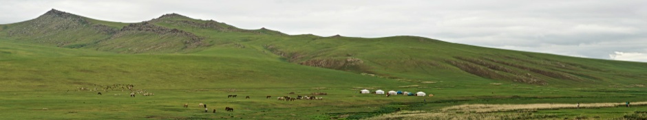
Nomad camp. ©2012 Robert Prior
Mongolian Landscape
I remember thinking that this was how Saskatchewan and Alberta must have looked before they were settled. Not the broad valleys between rocky hills, but the lack of permanent buildings. Of course there was the road, and the feeling of being in another world didn't really sink in until a couple of days later when we left paved roads and struck out cross-country for the Gobi, but right at the beginning of the trip I knew I'd arrived somewhere unlike anywhere else I've ever visited.
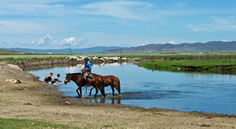
The other thing that struck me was the large numbers of animals. In Canada, farms are mostly for crops, and seeing cattle is fairly rare. In Mongolia, there are hardly any fields, but everywhere you look you can see sheep and goats and horses.
And flies. So many livestock produce a prodigious amount of dung, which means vast numbers of flies — small and annoying, but fortunately not biting.
It is easier to catch an escaped horse than to take back an escaped word.
Mongolian Proverb
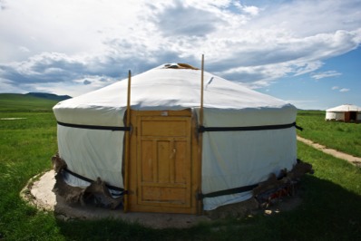
To the right you can see my ger.
The camp was beside a small stream, which wound into the hills behind the camp. It was a lovely location, and I could happily spend several days there.
I wanted to climb the hills, but quickly realized that even without carrying my usual camera gear it would be a hike of several hours, and I just didn't have the time.
Orkhon Valley. ©2012 Robert Prior
QTVR Image
Mongolian Herdsman
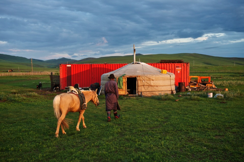
Herdsman's summer camp. ©2012 Robert Prior
At the end of a perfect day…
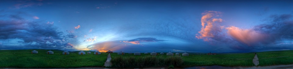
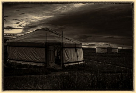
Sunset over Mongon Mod Kharkhorin Ger Camp. ©2012 Robert Prior
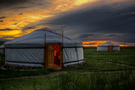
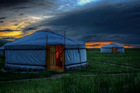
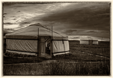
Gers at sunset, four treatments. ©2012 Robert Prior
Further travels in the Orkhon Valley Cultural Landscape
Continue reading about the Orkhon Valley here:
UNESCO Designation
Orkhon Valley clearly demonstrates how a strong and persistent nomadic culture led to the development of extensive trade networks and the creation of large administrative, commercial, military and religious centres. The empires undoubtedly influenced societies across Asia and into Europe and in turn absorbed influence from both east and west in a true interchange of human values. This culture is still a revered and indeed central part of Mongolian society and is highly respected as a 'noble' way to live in harmony with the landscape. The valley itself is an exceptional illustration of several significant stages in human history, reflecting its role as the centre of the Mongolian Empire, a special Mongolian variation of Turkish power, the Tuvkhun hermitage monastery as the setting for the development of a Mongolian form of Buddhism, and Khar Balgas as the capital of the Uighur Empire.
This cultural landscape is in central Mongolia, some 360 km south-west of Ulan Bator, the capital, along the Orkhon River, which flows north, draining into Lake Baikal across the border in Russia. Over 90% of Mongolia's huge land area is high-level pasture or desert wasteland, at an average altitude of around 1,500 m. Water is at a premium and the river valleys have therefore assumed great importance, becoming the focus for settlements of various kinds. In Mongolia, nomadic pastoralism, the grazing of horses, sheep, goats, cows and camels, is perceived as much more than the objective technical demands of pastoral life: it is revered and glorified as the heart of Mongolian culture. In turn Mongolian nomadic culture is part of a much wider distinctive nomadic pastoral culture, embracing many other people besides the Mongols and extending across central Asia. Over at least the past two millennia these nomadic cultures, through economic, political and cultural links, have made an immense impact on the sedentary cultures with which they interacted across Asia and into Europe. Nomadic pastoralists spent their lives moving their herds from one pasture to another, sometimes covering vast distances each year. They operated and moved across their territory within strictly regulated and controlled ways, linked to the specific designation and use of grazing grounds and to territorial rights and social units. Underpinning this movement were fixed points, which could be cities, providing centres of government, crafts, trade and commerce, or religious sites, such as temples and funerary areas. The density of such fixed points varied enormously across the vast Eurasian steppes.
Orkhon Valley Cultural Landscape is one of the key areas in Mongolia where the links between nomadic pastoralism and the associated settlements can be see most clearly, where there is a high density of remains, and where above all these remains are of national and international importance. Orkhon Valley was at the centre of traffic across the Asian steppes and became the capital of first the Uighur Empire and then the Mongol Empire, which described itself as 'the greatest empire the world has ever known'.
The broad, shallow river valley provides water and shelter, key requisites for its role as a staging post on the ancient trade routes across the steppes, such as those now known as the Silk Road, and for its development as the centre of two of the vast Central Asian empires.
The main monuments are open to the public. They include the Turkish Memorials of Khosho Tsaidam; the ruins of Khar Balgas City and Kharkhorum City; Erdene Zuu Monastery; Tuvkhun Hermitage Monastery; Shankh Western Monastery; the Palace at Doit Hill; the ancient towns of Talyn Dorvoljin, Har Bondgor and Bayangol Am; many deer stones and ancient graves; the sacred mountains of Hangai Ovoo and Undor Sant; and the long tradition of nomadic pastoralism.
Modern Mongolia comprises only about half of the vast Inner Asian region known throughout history as Mongolia. It is also only a fraction of the great Chinggis Khan's Mongul Empire, which in the 13th and 14th centuries stretched from Korea to Hungary, covering nearly all of Asia except the Indian sub-continent and parts of southeast Asia. It was the largest contiguous land empire the world has known. Many people from societies conquered by the Mongols have written about them - much unfavourable. On the other hand Mongol sources emphasise the almost god-like military genius of Chinggis Khan whose success rested not just on military skill but also on increasingly sophisticated administrative systems. The empire's success - over nearly two centuries - also depended on the absorption and employment of Chinese, Iranian, Russians and others. Mongolia and its people have thus had a significant and lasting impact on the historical development of major nations such as China and Russia, and periodically influenced the entire Eurasian continent.
Until the mid 20th century most of the people who inhabited Mongolia were nomads. The Mongols were one of several distinct nomadic peoples living in Mongolia who over the past two millennia have engaged in constantly shifting alliances, with centralised states such as the Huns, Syanbi, Jujuan, Turkic and Uighur Empires emerging from time to time between the 3rd century BC and the 9th century AD. Over the centuries, some nomadic peoples moved west to establish the Hun Empire in Europe while others moved into Iran, India and China.
For two centuries, the establishment of Chinggis Khan's Empire, with its centralised control, interrupted this pattern and put in place sophisticated military and political systems, which exceeded in skill and efficiency most others of the time. Under Chinggis and his successors, the Moguls conquered most of Eurasia.
In the early 16th century with the waning of the empire, Mongolia once again became a land of warring factions. From the late 17th to the early 20th centuries, Mongolia was a major focus of Russian and Manchu-Chinese rivalry, leading eventually to the fragmentation of Mongolia, with Inner Mongolia (the south part of Mongolia) being absorbed by the Chinese and with increasing Russian interest in Outer Mongolia. Russia's predominance in Outer Mongolia was unquestioned by 1921 and in 1924 the Mongolian People's Republic was established - under the control of Moscow. Mongolia became an independent State in 1946.
Today more Mongolians - around 3.5 million - live in Inner Mongolia, China, than in the Mongolian People's Republic, which has a population of 2.7 million.
This cultural landscape is in central Mongolia, some 360 km south-west of Ulan Bator, the capital, along the Orkhon River, which flows north, draining into Lake Baikal across the border in Russia. Over 90% of Mongolia's huge land area is high-level pasture or desert wasteland, at an average altitude of around 1,500 m. Water is at a premium and the river valleys have therefore assumed great importance, becoming the focus for settlements of various kinds. In Mongolia, nomadic pastoralism, the grazing of horses, sheep, goats, cows and camels, is perceived as much more than the objective technical demands of pastoral life: it is revered and glorified as the heart of Mongolian culture. In turn Mongolian nomadic culture is part of a much wider distinctive nomadic pastoral culture, embracing many other people besides the Mongols and extending across central Asia. Over at least the past two millennia these nomadic cultures, through economic, political and cultural links, have made an immense impact on the sedentary cultures with which they interacted across Asia and into Europe. Nomadic pastoralists spent their lives moving their herds from one pasture to another, sometimes covering vast distances each year. They operated and moved across their territory within strictly regulated and controlled ways, linked to the specific designation and use of grazing grounds and to territorial rights and social units. Underpinning this movement were fixed points, which could be cities, providing centres of government, crafts, trade and commerce, or religious sites, such as temples and funerary areas. The density of such fixed points varied enormously across the vast Eurasian steppes.
Orkhon Valley Cultural Landscape is one of the key areas in Mongolia where the links between nomadic pastoralism and the associated settlements can be see most clearly, where there is a high density of remains, and where above all these remains are of national and international importance. Orkhon Valley was at the centre of traffic across the Asian steppes and became the capital of first the Uighur Empire and then the Mongol Empire, which described itself as 'the greatest empire the world has ever known'.
The broad, shallow river valley provides water and shelter, key requisites for its role as a staging post on the ancient trade routes across the steppes, such as those now known as the Silk Road, and for its development as the centre of two of the vast Central Asian empires.
The main monuments are open to the public. They include the Turkish Memorials of Khosho Tsaidam; the ruins of Khar Balgas City and Kharkhorum City; Erdene Zuu Monastery; Tuvkhun Hermitage Monastery; Shankh Western Monastery; the Palace at Doit Hill; the ancient towns of Talyn Dorvoljin, Har Bondgor and Bayangol Am; many deer stones and ancient graves; the sacred mountains of Hangai Ovoo and Undor Sant; and the long tradition of nomadic pastoralism.
History
Modern Mongolia comprises only about half of the vast Inner Asian region known throughout history as Mongolia. It is also only a fraction of the great Chinggis Khan's Mongul Empire, which in the 13th and 14th centuries stretched from Korea to Hungary, covering nearly all of Asia except the Indian sub-continent and parts of southeast Asia. It was the largest contiguous land empire the world has known. Many people from societies conquered by the Mongols have written about them - much unfavourable. On the other hand Mongol sources emphasise the almost god-like military genius of Chinggis Khan whose success rested not just on military skill but also on increasingly sophisticated administrative systems. The empire's success - over nearly two centuries - also depended on the absorption and employment of Chinese, Iranian, Russians and others. Mongolia and its people have thus had a significant and lasting impact on the historical development of major nations such as China and Russia, and periodically influenced the entire Eurasian continent.
Until the mid 20th century most of the people who inhabited Mongolia were nomads. The Mongols were one of several distinct nomadic peoples living in Mongolia who over the past two millennia have engaged in constantly shifting alliances, with centralised states such as the Huns, Syanbi, Jujuan, Turkic and Uighur Empires emerging from time to time between the 3rd century BC and the 9th century AD. Over the centuries, some nomadic peoples moved west to establish the Hun Empire in Europe while others moved into Iran, India and China.
For two centuries, the establishment of Chinggis Khan's Empire, with its centralised control, interrupted this pattern and put in place sophisticated military and political systems, which exceeded in skill and efficiency most others of the time. Under Chinggis and his successors, the Moguls conquered most of Eurasia.
In the early 16th century with the waning of the empire, Mongolia once again became a land of warring factions. From the late 17th to the early 20th centuries, Mongolia was a major focus of Russian and Manchu-Chinese rivalry, leading eventually to the fragmentation of Mongolia, with Inner Mongolia (the south part of Mongolia) being absorbed by the Chinese and with increasing Russian interest in Outer Mongolia. Russia's predominance in Outer Mongolia was unquestioned by 1921 and in 1924 the Mongolian People's Republic was established - under the control of Moscow. Mongolia became an independent State in 1946.
Today more Mongolians - around 3.5 million - live in Inner Mongolia, China, than in the Mongolian People's Republic, which has a population of 2.7 million.
Wikipedia Articles
Orkhon Valley Cultural Landscape (Mongolian: Орхоны хөндийн соёлын дурсгал) sprawls along the banks of the Orkhon River in Central Mongolia, some 320 km west from the capital Ulaanbaatar. It was inscribed by UNESCO in the World Heritage List as representing evolution of nomadic pastoral traditions spanning more than two millennia.
For many centuries, the Orkhon Valley was viewed as the seat of the imperial power of the steppes. The first evidence comes from a stone stele with runic inscriptions, which was erected in the valley by Bilge Khan, an 8th century ruler of the Göktürk Empire. Some 25 miles to the north of the stele, in the shadow of the sacred forest-mountain Ötüken, was his Ördü, or nomadic capital. During the Qidan domination of the valley, the stele was reinscribed in three languages, so as to record the deeds of a Qidan potentate.
Mountains were considered sacred in Tengriism as an axis mundi, but Ötüken was especially sacred because the ancestor spirits of the khagans and beys resided here. Moreover, a force called qut was believed to emanate from this mountain, granting the khagan the divine right to rule the Turkic tribes. Whoever controlled this valley was considered heavenly appointed leader of the Turks and could rally the tribes. Thus control of the Orkhon Valley was of the utmost strategic importance for every Turkic state. Historically every Turkic capital (Ördü) was located here for this exact reason. There were many houses by the bank but they are all gone now.
The main monuments of the Orkhon Valley are as follows:
The Erdene Zuu Monastery (Mongolian: Эрдэнэ Зуу) is probably the most ancient surviving Buddhist monastery in Mongolia. It is in Övörkhangai Province, near the town of Kharkhorin and adjacent to the ancient city of Karakorum. It is part of the World Heritage Site entitled Orkhon Valley Cultural Landscape.
The Erdene Zuu monastery was built in 1585 by Abtai Sain Khan, upon the (second) introduction of Tibetan Buddhism into Mongolia. Stones from the ruins of Karakorum were used in construction. It is surrounded by a wall featuring 100 stupas. The number 108, being a sacred number in Buddhism, and the number of beads in a Buddhist rosary, was probably envisioned, but never achieved. The monastery temples' wall were painted, and the Chinese-style roof was covered with green tiles. The monastery was damaged by warfare in the 1680s, but was rebuilt in the 18th century and by 1872 had a full 62 temples inside.
In 1939 the Communist leader Khorloogiin Choibalsan had the monastery ruined, as part of a purge that obliterated hundreds of monasteries in Mongolia and killed over ten thousand monks. Three small temples and the external wall with the stupas remained; the temples became museums in 1947. They say that this part of the monastery was spared destruction on account of Joseph Stalin's pressure. One researcher claims that Stalin's pressure was connected to the short visit of US vice president Henry A. Wallace's delegation to Mongolia in 1944.
Erdene Zuu was allowed to exist as a museum only; the only functioning monastery in Mongolia was Gandantegchinlen Khiid Monastery in the capital, Ulaanbaatar. However, after the fall of Communism in Mongolia in 1990, the monastery was turned over to the lamas and Erdene Zuu again became a place of worship. Today Erdene Zuu remains an active Buddhist monastery as well as a museum that is open to tourists.
On a hill outside the monastery sits a stone phallus. The phallus is said to restrain the sexual impulses of the monks and ensure their good behaviour.
For many centuries, the Orkhon Valley was viewed as the seat of the imperial power of the steppes. The first evidence comes from a stone stele with runic inscriptions, which was erected in the valley by Bilge Khan, an 8th century ruler of the Göktürk Empire. Some 25 miles to the north of the stele, in the shadow of the sacred forest-mountain Ötüken, was his Ördü, or nomadic capital. During the Qidan domination of the valley, the stele was reinscribed in three languages, so as to record the deeds of a Qidan potentate.
Mountains were considered sacred in Tengriism as an axis mundi, but Ötüken was especially sacred because the ancestor spirits of the khagans and beys resided here. Moreover, a force called qut was believed to emanate from this mountain, granting the khagan the divine right to rule the Turkic tribes. Whoever controlled this valley was considered heavenly appointed leader of the Turks and could rally the tribes. Thus control of the Orkhon Valley was of the utmost strategic importance for every Turkic state. Historically every Turkic capital (Ördü) was located here for this exact reason. There were many houses by the bank but they are all gone now.
The main monuments of the Orkhon Valley are as follows:
- Sculpted marble head of the Göktürk general Kul Tigin. Discovered in the Orkhon Valley.
- The so-called Orkhon monuments are early 8th-century Turkic memorials to Bilge Khan and Kul Tigin, the most impressive monuments from the nomadic Göktürk Empire. They were discovered and by Russian archaeologists in 1889, and deciphered by Vilhelm Thomsen in 1893.
- Ruins of Khar Balgas, an 8th-century capital of the Uyghur Empire, which cover 50 square km and contain evidence of the palace, shops, temples, monasteries, etc.
- Ruins of Genghis Khan's capital Karakorum which could have included the famed Xanadu palace.
- Erdene Zuu monastery is the first Buddhist monastery established in Mongolia. It was partly destroyed by Communist authorities in 1937-40.
- Tuvkhun Hermitage is another spectacular monastery, overlooking a hill at 2,600 m. above sea-level. Likewise, it was almost totally destroyed by the Communists.
- Remains of the 13th and 14th century Mongol palace at Doit Hill, thought to be Ögedei Khan's residence.
The Erdene Zuu Monastery (Mongolian: Эрдэнэ Зуу) is probably the most ancient surviving Buddhist monastery in Mongolia. It is in Övörkhangai Province, near the town of Kharkhorin and adjacent to the ancient city of Karakorum. It is part of the World Heritage Site entitled Orkhon Valley Cultural Landscape.
The Erdene Zuu monastery was built in 1585 by Abtai Sain Khan, upon the (second) introduction of Tibetan Buddhism into Mongolia. Stones from the ruins of Karakorum were used in construction. It is surrounded by a wall featuring 100 stupas. The number 108, being a sacred number in Buddhism, and the number of beads in a Buddhist rosary, was probably envisioned, but never achieved. The monastery temples' wall were painted, and the Chinese-style roof was covered with green tiles. The monastery was damaged by warfare in the 1680s, but was rebuilt in the 18th century and by 1872 had a full 62 temples inside.
In 1939 the Communist leader Khorloogiin Choibalsan had the monastery ruined, as part of a purge that obliterated hundreds of monasteries in Mongolia and killed over ten thousand monks. Three small temples and the external wall with the stupas remained; the temples became museums in 1947. They say that this part of the monastery was spared destruction on account of Joseph Stalin's pressure. One researcher claims that Stalin's pressure was connected to the short visit of US vice president Henry A. Wallace's delegation to Mongolia in 1944.
Erdene Zuu was allowed to exist as a museum only; the only functioning monastery in Mongolia was Gandantegchinlen Khiid Monastery in the capital, Ulaanbaatar. However, after the fall of Communism in Mongolia in 1990, the monastery was turned over to the lamas and Erdene Zuu again became a place of worship. Today Erdene Zuu remains an active Buddhist monastery as well as a museum that is open to tourists.
On a hill outside the monastery sits a stone phallus. The phallus is said to restrain the sexual impulses of the monks and ensure their good behaviour.